Click
the picture or this text to see the buttes photo full size
It's a 51 K file, could take 20 seconds to load at 28.8; worth it, I think.
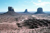
Taken from Lookout Point at the Navaho
tribe's park headquarters, in the middle of an April morning, this photo of West
Mitten Butte, East Mitten Butte, and Merrick Butte is a little trite, but still
awe-inspiring.
As is true in much of this land, there is constant wind,
usually rolling straight down from the North. Although not easily discerned from
a still photograph, the effects of the moving air are displayed at every step.
Footprints in dust are erased in minutes, if not seconds. Ridges that seem sharp
at a distance are rounded in detail. Fine particles of dirt or sand raised by
passage of a truck are distributed, dissipated, and diluted so rapidly there is
no "cloud of dust."
There are long-load satellite photos and a map from USGS:
To see a North-to-top
map of the area <-- click there.
(20 K)
A click here shows a wide
vertical view from the same East-to-top orientation as the photograph. (34 K)
A click here shows a narrower
vertical view of the view point and the ripples in the foreground. (19K)
A click on West Mitten Butte reveals
a narrow vertical view.
(20 K)
