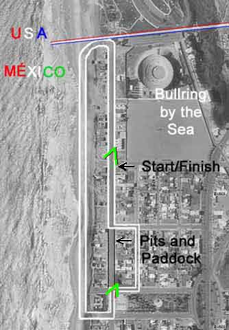
An aerial
view (USGS) of Playas de Tijuana, México,
overlaid by a course diagram.
The carats are clickable for photo views:
Upper will show the SCG photo of
Start-Finish from a restaurant's second story; lower
will show Vern Jaques' shot of YOBS' MGB in the indicated location.
As you look at the second photo, imagine the street I am turning onto
runs down to the right like the one the TR is emerging from. Pit entry
was from the left of the beach straight, up that hill, and left along
the edge of the street the Porsche is on. Another view of this turn
is available here.
I have copies of the original track diagram I supplied to racers. The
sheets were duplicated on a mimeo machine and showed street widths I
measured from curb to curb. I designed the course to incorporate two
right turns. The previous layouts had been all left handers, kind of
a long, squared oval.
During the rain race a formula car missed the north turn, hit the curb
and vaulted the two-strand barbed wire fence at the borderline. Several
spectators and a couple of flagmen slogged through the mud, righted
the car and dragged it back into Mexico. Quite a set of tracks for the
Border Patrol specialists to figure out.
|

