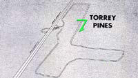
Here it is, at last. To see
a large version in a new window, click the thumbnail above; to see it in this
same window, click here.
This
diagram of the course is said to represent "...how Torrey Pines, California's
most fascinating raceway, appears from 10,000 feet." The picture (minus S/F
and direction information), was printed in the program for November, 1953, sports
car races on March Air Force Base, near Riverside, California.
The longest
dimension of the track runs roughly parallel to Pacific Coast Highway (Route 101).
North is at the bottom of the picture, the Pacific Ocean to the right.
March AFB is less than a mile south of the location where Riverside
International Raceway was built and eventually disassembled. To see the shape
of March Air Force Base's course, click here.


