BOTTOM of PageBack BOTTOM of Page
RIR Pictures Pages
Diagram Overlaid on USGS Satellite Photo
Annotated but no longer With Hot-Spot Links
to Contemporary and Other Photos
GIF:  RIR logo jacket patch

<<<    BACK to RIR Pics 1
NEXT RIR Pics 1b   >>>
RIR Pics 2 Page begins with Start-Finish
RIR Pics 3 Page begins after Turn Two
RIR Pics 3b Page begins at Turn Six
RIR Pics 4 Page begins with Turn Seven
RIR Pics 5 Page begins at Turn Eight
RIR Pics 6 Page Grand Prix Legends simulator frames
RIR Pics 7 Page is from a 1957 Sports Illustrated report
RIR Pics 7b Page 1960 Formula One Grand Prix SI report
RIR Pics 8 Page et seq. show 8mm film frames of a Riverside long course lap
RIR Pics 9 Page Autoweek's RIR Requiem article

These pages are for the education, edification and entertainment of diehard Riverside International Raceway fans
(Speaking of nostalgia—look at the warning I felt was necessary when these pages were first published, back in the Dial-up Age: "There could be very, very long loads at 28.8: maybe as much as 50 seconds; your mileage may vary")
Check back frequently: I will add material as I find it

Don't forget to refresh when you come back

NOTE:  A click on these < carets <angle brackets>
no longer reveals a photo view.

(All photos were enabled as of 25 September 2002; small chance I'll get them hooked up as before. More likely a page with all the photos rather than individual html connections.)

Legend:  Red lower case letters designate photo points as set out below
             Green carats show (very) approximate photo directions
                       I've tried to keep photos other than this one below 40K
             Black "o" circles the RIR sign near Highway 60 and Day Street
             Unmarked surprise hot spots will abound (hover the cursor for clues)


About the environment: it was Saturday, a couple hours after noon, second weekend of February, 2002. Strong winds were tipping high-profile vehicles east, west, north and south of here. At the old racing ground, there was constant air movement and some gusts, but it was not intolerable.

Inhibited from the beginning, we found each of those carefully planned wide and dramatic streets within the commercial and residential areas labeled "No Stopping At Any Time." Two lanes and a bike path in each direction. If you want to park, by golly you better be reconciled to doing it in a parking lot. Some of the lots were well-populated, but there was no competition for parking.

Security was a prominent presence in the commercial areas to the north (bounded by "a", "c", "s", "b"), none that I saw at Costco ("d"). An odd little glass shack in the Turn Eight area held an "officer" overseeing a lot with only a dozen cars in it. We did not go into the mall(s).

We spent most of our time in the northern parts of the site. From a vantage in the high vacant lot around "a" you can get the same sense of "South is definitely downhill" as was obvious in racing days. Some of the abrupt elevation changes have been smoothed: the hill where the Turn Seven north-facing bleachers stood is just not discernible (Turn Seven is also in a vacant lot). The Turn Five-Six uphill and the cut hill between Seven and Eight must have been flattened to accommodate the foundation of major mall structures that now occupy the place.

Additional pages
reached by following the lower-case links will show or inform you about features in those areas. You'll see (at least) three photos of the RIR marquee sign, then still standing near Day Street and Highway 60. It earned prominent display through the not-so-subtle device of being the sole remaining feature I could actually identify. And I'm not so sure they didn't move that on me. Click HERE to see a photo of the way it was on the Last Lap weekend. Click HERE to see how it looked on the Trans-Am weekend, 1969.


July 22, 2002: I have word from Dr. Michael Cornelison that the marquee sign was removed on or about July 17, 2002. It seems Lowe's, a national hardware chain, has begun construction of an outlet on the premises.

September 25, 2002: The Riverside Press-Enterprise reports there is coordination among enthusiasts and Moreno Valley City officials to the end of creating a Riverside International Raceway memorial in a city park and community center now under development. I have initiated correspondence with the city, hoping to be notified of completion and dedication dates, projected in the article as spring or summer, 2003.

September 27, 2002
: I've been out of the loop until today. Richard "rdrcr" very kindly pointed me to the AtlasF1 Bulletin Board's The Nostalgia Forum, where there is a "Riverside Today" thread. There you can see the inception of a tribute to RIR, which through Richard's capable offices and a commitment by Moreno Valley officials will eventually result in an appropriate monument in a choice location. Go to the Forum and RIR thread to get the latest information and see an example of a projected design. Great news.

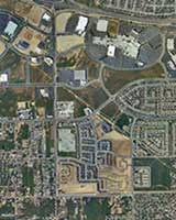
December 13, 2003: Jason Trew sent a message pointing out the final erasure of every last trace of the race track is now confirmed on GlobeXplorer.  Click the "thumbnail" to see a 112K version of this aerial view dated March 3, 2003.

CLICK to see a 1ooK ???x760 view

Click  H E R E  to learn about
the Monument project.


December 11, 2006:  My sister Sandy and I visited the Moreno Valley Community Center, located near the (former) west entry to the (formerly) Champion bridge, site the anticipated monument and of a (purported) elaborate display of memorabilia dedicated to RIR memories. Yes, was there; no, it wasn't proportional to the former glory embodied in Riverside International Raceway and all it meant to the many participants and spectators.

I haven't been back to see if it's still on show, but I'd bet against it.


TOP of Page

<<<   BACK to RIR Pics -1-                    
   NEXT RIR Pics -1b-   >>>
RIR Pics -2-
RIR Pics -3-
RIR Pics -3b-
RIR Pics -4-
RIR Pics -5-
RIR Pics -6-
RIR Pics -7-
RIR Pics -7b-
RIR Pics -8-
RIR Pics -9-

  TOP of Page


In San Diego CA:
Click for Montgomery, California Forecast
Back